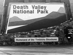

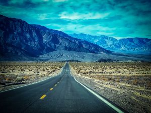
A Perfect Weekend in Death Valley National Park
Let’s be clear. You can spend a week in Death Valley National Park and still not feel like you saw or experienced everything. This is a huge, and spectacular park, often overlooked by travelers, and I’m sad to say, I’ve probably been to Las Vegas close to a dozen times, and this was my first dip into this park that is only 2 hours away.
Death Valley National Park takes some planning and forethought on time of year, and navigating the terrain. Unless you are doing a day trip on a tour to Death Valley National Park from Las Vegas, which I think would be a great way to see the park for a first time visitor, you’ll need to do some planning. For details on that, check out my other posts on Restaurants and What I Wish I’d Known Before I Went to Death Valley.
 .
.  .
. 
Perfect Itinerary
For this Itinerary, you may wonder – why not go just from A-B-C in logical order? I will tell you why, because that is what EVERYONE does. I would much rather head to the end, and work my way back, just for the main reason – to avoid the crowds. This itinerary worked perfect for us, and I think it will for you as well. However, I always recommend to put these into your iPhone or app that allows for multiple stops, then start out with this as the plan (please have a paper map as well), and then if you drive past an empty parking spot for something else, take a quick turn and change it up! It is BEST to have a plan set on your chose app, since wifi is non-existent once you leave the resort area, so being prepared will come in very handy.
Arrival Day (if just the afternoon/evening):
SouthWest of Pahrump and South of Death Valley is a free area that is perfect for your arrival day with a few quick spots worth seeing.
 .
. 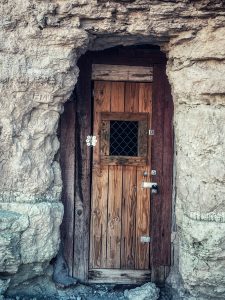
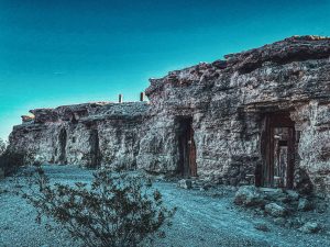
(1) Dublin Gulch
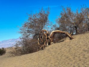
Dublin Gulch is 30 minutes, 28miles, from the town of Pahrump, Nevada. Take Hwy 327 SW changing to Hwy 178 to the small town of Shoshone, California. Park near the unmarked trailhead on the side of the road in the large gravel area (across from the Crowbar Cafe). There is a 0.5mile loop, flat, easy trail that meanders through the small hillside old cemetery leading you out to the Dublin Gulch. Dublin Gulch are miner-carved caverns that people actually lived in with some very interesting history. This was even a hiding spot for targets of the infamous Charles Manson. You can peek inside the wooden doors to the caverns. There was not another soul around, that we saw anyway, and we enjoyed exploring the area.
Optional Add-on: Crowbar Cafe is a classic cafe and Shoshone Village Museum is a very small historical museum in the same area.
 .
. 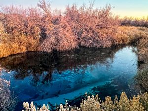
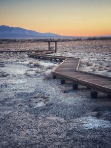
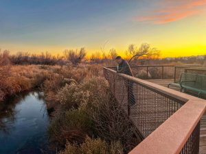
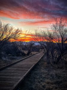
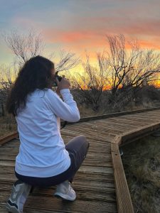
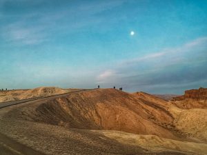
(2) Crystal Marsh Loop at Ash Meadows National Wildlife Refuge (bonus points if you time this for sunset)
This was my first “WOW” of the majestic beauty of the desert, and quite possibly my favorite spot overall. Helps that we ended up there right at sunset – the sunset in the desert is no joke, STUNNING!, and even better that we had the boardwalk to ourselves.
From Dublin Gulch and Shoshone, CA drive 42 miles (47min North – use directions) to the Ash Meadows National Wildlife Refuge. A beautiful interpretive center (wasn’t open when we arrived) and is in the Amargosa Valley, just outside of Death Valley National Park.
Crystal Marsh Loop was a flat, well-maintained, lifted boardwalk known for birding opportunities (sometimes pupfish) and some absolutely stunning, ice blue water on the far end of the balloon shaped loop. You can easy walk the just under a mile loop this in about 15-20min, but you’ll want extra time for photos, observing nature, especially if at dusk. We saw a large jack rabbit and watched it for awhile, and stayed out long into the sunset time as the colors of the desert just got better and better. It was wicked cold, so dress accordingly if it is evening. As hot as the desert gets in the day, it gets very cold at night. Wheelchair accessible and dogs on leashes are welcome.
 .
.  .
. 
Optional Add ons:
Point of Rocks Springs
This is located near the Ash Meadows National Wildlife Refuge as well, and is a 0.5mile easy boardwalk with desert views, mesquite trees, Kings Pool with the beautiful blue water, and benches along the way. Open to wheelchairs and dogs on leashes as well. Similar to Crystal Marsh Loop, so pick one that has less people or is convenient to you.
Longstreet Boardwalk
Also accessible from the parking lot, wheelchair accessible, and dogs on leashes welcome, this is a very short 0.11 trail to a stone cabin.
Devils Hole Overlook
A quick stop just past Crystal Marsh Loop, Devils Hole Overlook is A spot to look down into the crevice and see pupfish that are being studied here by scientists. Best time to see these fish would be in late summer when their population is highest. Biologists are working hard at increasing what was a dwindling population. It is a fascinating geological site that has the water “shaking” when Mexico and again Alaska had significant earthquakes.

Full Day Death Valley National Park Highlights Itinerary
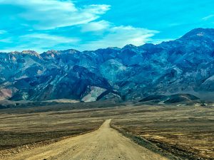
Now this encompasses most of the Southern and Central areas of Death Valley National Park. Depending on the time of year, weather, and crowds, you can breeze through all of it (if not doing each hike to its length) to get a taste of all that Death Valley has to offer, or this could be split between several days and leisurely, fully explored ideally.
Now due to washed out roads in the Northern and other areas of the park, we were unable to check out a few spots that are bucket list material for another trip. We were lucky to explore all nine of these locations in one long winter day, but would have like more time to deeper explore some of the trails and hit up other spots I’ve listed on this post that due to time restraints and closed roads, were impossible at the time.
 .
.
 .
. 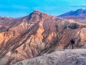
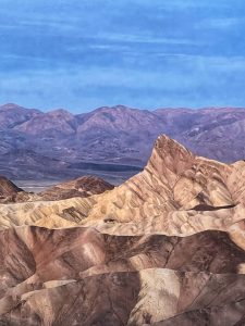
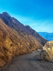
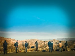
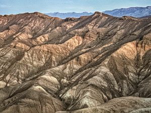
(1) Zabriskie Point (at Sunrise)
Zabriskie Point is one of the best things you can do in Death Valley National Park, and well worth the middle of the night drive to get there well before sunrise. We bundled up, and even though I had a heavy coat, scarf, hat, and a blanket, it was a very cold experience. That being said, I would absolutely go there again, any chance I could. This place can get very busy, so arrive early and join the lineup of photographers up the short path to catch the sunrise. I found that the views were best looking away from the sunrise, capturing the light on the hills. This is where you really get to see the gorgeous textures of the desert landscape. Next time I will take the time to do the 2.7mile loop of the Badlands via Zabriskie Point Trail and Gower Gulch Path starting from the Zabriskie Point parking lot. I could see the trail winding through the hills and it was magical. This is a moderate trail with an elevation change of only 413ft. Go counterclockwise for the best views.
 .
. 
 .
. 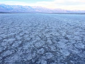
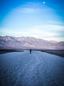
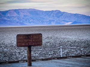
(2) Badwater Basin Salt Flats Trail
Badwater Basin is your next stop, and as you drive, you may be wondering why we pass so many other spots on the way. Go about the route as you choose, but as I explained above, heading to the furthest location on a road and working your way back is a great way to avoid the crowds. Now this spot is advertised as a 1.9mile flat, easy hike with a boardwalk. Reality – it has a boardwalk, for about 2 mins, then you are walking on the salt flats for the remainder. I don’t consider this a “trail”, but it is very walkable. We didn’t walk further than about 10min out, however if there were a lot of people, then I’d recommend walking out far enough past the crowds to get a piece of this surreal landscape to yourself. At this location you are 282 ft below sea level. To get a full perspective, please look back towards the cliff side on the other side of the parking lot and search the cliff wall for the sign that shows were sea level is. The salt flats have a distinct cracked surface appearance that is picturesque. Off to the right near the water “basin” you can see how the crystallized salt can build up to create very coarse, lumpy structures.
 .
. 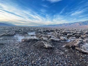
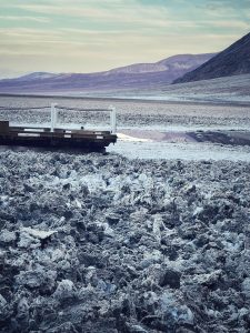
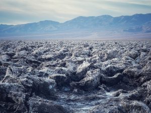
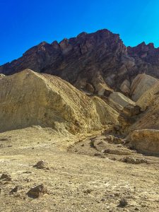
(3) Devil’s Golf Course
Return back on the road you were on until you see the cut-off for Devil’s Golf Course. This is an unpaved road (the first of many you will travel) but is well maintained (at the time of this post) and easily navigated. This road will land you in what appears to the center of this great valley, and a prime spot to see the crystallized salt structures. There is no trail, this is just a view point, but worth the stop. These jagged structures were the result of ancient salt lakes and sculpted by rain and wind. It is a continuously changing environment and on a warm day you may even hear the crackling sound of salt pinnacles expanding and contracting. Please respect the landscape and do not touch or walk onto the salt. Besides being destructive, it is also dangerous.
(4) Furnace Creek Visitor Center
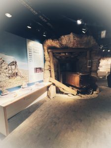
By this point in my morning, I was seeking coffee, A bathroom and some food. So we headed back to Furnace Creek and attempted the resort dining room (more on that in the post on Restaurants). If you aren’t needing a break yet, then maybe jump ahead to #6, 7, or 8 first. Furnace Creek Visitor Center has excellent interpretive displays, a video, and very knowledgable rangers to help guide you with a park pass if you haven’t gotten it already, help with some trail ideas, and give you the latest info on road conditions, hazards, etc. There are also prepackaged drinks and sandwiches to go for a quick lunch on the trail.
 .
. 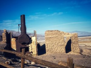
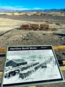
(5) Harmony Borax Interpretive Trail
This short paved, easy trail winds 0.4 miles around the preserved site of Harmony Borax Works. Originally built in 1882, you can look at interpretive signs along the way as you marvel at the ability to refine the borax on site and then transport it by wagon 165 miles across the desert to the closest railroad.
 .
. 
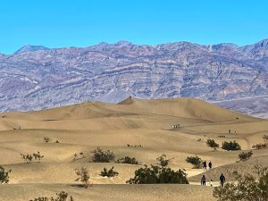
(6) Mesquite Flat Dunes
A 20 min drive from Harmony Borax Interpretive Trail will take you to Mesquite Flat Dunes. A classic desert landscape of soft ripples of fine sand. You’ll see people trekking out to the tallest dune about 2 miles away, but don’t let that convince you that its an easy walk. Take a few dozen steps up the first molehills and you’ll quickly see that it will be a workout for your legs if you go very far. No obvious “trail” its more of a free-for-all attempt to navigate the dunes. This spot is best observed in the morning to see it without the millions of footprints, or evening as the light shines on it and creates multiple tones in the sand. Mid-day during the summer is an absolute no, and a guarantee of heat stroke. Don’t attempt it. As you can see from our photo, it wasn’t the ideal conditions as we stumbled upon it when we could, not for the best lighting. See the Flat Dunes is a must for your itinerary. A site you won’t likely forget.
 .
.  .
.
 .
. 
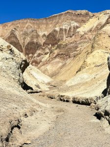
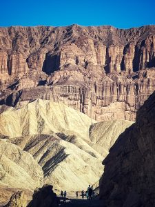
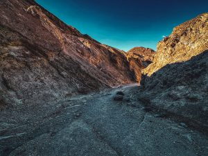
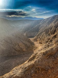
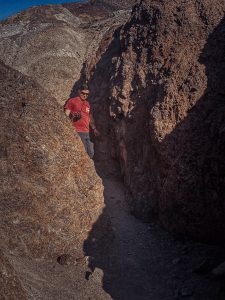
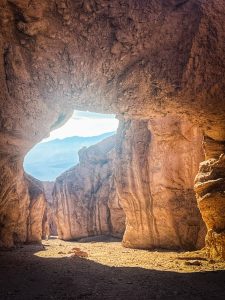
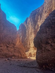
(7) Golden Canyon Trailhead
This was my favorite actual hike that we did. As you can see so far, so many of the “trails” aren’t much more than A stop. This was the first one that we felt we were into the depths of the desert and without sight of our car.
Golden Canyon Trailhead is 0.8miles, but can be extended by multiple unmarked trails or a few marked routes that can take you through the canyons to Zabriskie point and back in a 7+ mile loop. This was beautiful country, and only a few steps will take you into a magical landscape you can’t find elsewhere. My husband was entertained by hearing that Star Wars used this trail as a film site for many scenes. If you are a Star Wars fan, maybe consider bringing some light sabers for a memorable photo or two.
 .
. 
 .
. 
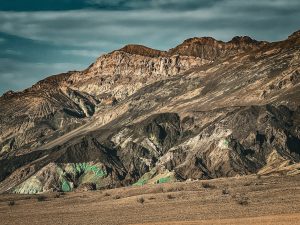
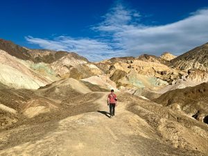
(8) Artists Palette
Artist Palette is A one-way drive with several spots for quick parking and getting out and ambling around rocks for views of what instagram would have you believe is a CandyLand colored hillsides that look like cotton candy of all different vibrant colors. Don’t get me wrong, it is pretty, and there are tinges of pink and turquoise, but the over exposed, over edited photos are not reality. Another Star Wars film site, this spot is a must to get out and wander around. I found in my research several “trails” from 0.3m-4.5m, but what I found was a great place to amble around on the ledge, then down around in winding trails, nothing distinctive of “here’s the trail you must do!”. Enjoy the experience, drive a little further, pull over where other cars are at or the parking lot areas and explore a little more. Head up a hillside and check out the views from different angles. I found that look back out over the large valley was even more impressive than trying to get as close as possible to the colored hillside.
 .
.  .
. 
(9) Natural Bridge Trail Head
This was the roughest road that we travelled. Saw several small cars and low mini-vans bounding over the bumps and diving down in the divots, but I wouldn’t recommend it. A good reminder to look ahead on the website, check with the rangers, and get a clear idea of what each road that you want to travel looks like, as it can change rapidly. Maybe by the time you go on this road it will be smooth as butter, yet another one might be completely impassable. Don’t be fooled into going off road to that softer looking area, sand is another devastating mistake that can be made, and then you are stuck as well.
 .
.
Nearby Spots if you have more time!
We didn’t check any of these out on this trip, but here’s a few more if you have more time to explore.
Dante’s View Trail & Overlook
At an elevation of 5476ft this is an overlook well worth driving up and taking the 1 mile trail to the top. It is an easy trail of only 223 ft elevation change. It was closed due to winter conditions when we were there in December 2022.
Twenty Mule Team Overlook & Hike
An easy 0.3mile hike, this is a quick stroll with high rewards. It showcases the diversity of textures over the landscape of Death Valley National Park. It is located close to Zabriskie Point.
Desolation Canyon
A great way to escape the crowds, you are sure to see less casual tourists on this 4.2 mile moderate hike that has an elevation change of approx 720ft. Off an unmarked road (check maps, AllTrails, or ask a ranger), few people find this trail although not difficult to navigate if you look it up first. Starting off unimpressive for the first mile it then narrows into A canyon for a change in landscape as you continue on. There is some rock climbing up dry falls, and several side canyon trails. If Artists Palette was full of traffic, then this spot might be worth it to get some colored hillsides all to yourself!
 .
.
Last Day – short, especially if driving back to Las Vegas
*Option #1 –
Hit up any of the Full Day stops that you didn’t get to the day before. Consider adding in Mosaic Canyon Trail if roads are open and feeling the desire for more hiking.
Mosaic Canyon
An easy to moderate trail, 3.6miles in length roundtrip (2-3hrs), weaves you through a beautiful multi-colored rock canyon. Quick possibly my biggest regret during this trip was missing this magical spot. Next time…
*Option #2 –
If not heading back into the park, check out Beatty, NV. This small town a bit further north has Beatty Museum for some local history, Goldwell Open Air Museum for some fun photo ops and artwork, as well as Rhyolite for a ghost town experience.
Beatty Museum
Worth a quick stop if in the area for Goldwell Open Air Museum and Rhyolite Ghost Town. Limited hours of operation, so check first before heading that way to make sure it is open. Small museum that covers the history of the area.
Goldwell Open Air Museum
A very odd collection of large outdoor artwork that will be sure to make you ponder the deeper meaning of the artwork pieces. If you have insights, drop me a note on your thoughts! This is right outside of Rhyolite Ghost Town, you can’t miss it. There is something striking about huge artwork placed in the open expansiveness of a desert. For another peek at some amazing artwork in the middle of a desert, check out my post on Galena Meadows Sculptures scattered in the Anza-Borrego Desert State Park outside of Palm Springs, California.
Rhyolite Ghost Town
10 minutes outside of Beatty, Nevada is Rhyolite Ghost Town. Nevada has several ghost towns, which any would be fun for a quick visit. This is a self guided walk around the buildings and can be a 1.1 mile loop if you so choose..
*Option #3 –
If heading out early and wanting a totally different desert experience, take the 5-6hr drive back to Las Vegas by driving the Alien Hwy 95, and getting as close as you can to Area 51. There are two stops that are a must, Area 51 Alien Center to stretch your legs and marvel at the alien obsession, and Little A’Le’Inn diner for a bite on your route. Ok, maybe a 3rd stop is needed for a picture at one of the highway signs proving you drove the Alien Hwy and survived. Please drive careful, this is a known highway for accidents. If you have driven this route, please leave a comment in the notes of your experience.
*Option #4 –
On your way out of the area, Pahrump has a great wine tasting spot, Artesian Cellars, with a great menu of light bites as well. Along the highway just North of there is Big Dune Sand Dunes. Both would be great spots for a taste of something different with the desert.
Artesian Cellars
My husband, James’s claim to fame of finding the best spot I would have chosen to drive right past. Wine in the Nevada desert? Nope, this wine snob wouldn’t have considered it. And I would have been dead wrong. Some of the best wine I’ve tasted. Was it partly due to a busy day of hiking? Possibly, but I stand by my statement that this place is worth the stop. Thank you James for being stubborn and pulling into the parking lot.
Big Dune
This was hot on my list of places to see, but I didn’t hit it at the right timing. Massive, gorgeous sand dunes right off Hwy 95. Less people than at the Mesquite Sand Dunes in Death Valley National Park, and arguably easier accessed due to location to the main highway. As with any sand dunes, best to see it in the morning light after the night winds have smoothed the footprints away and less people are there. This area is also used for ATV play, so I would avoid weekends or mid-late day if you want the picturesque sand dunes look.
 .
.
Deep in the Desert / Further Out Adventures
Assuming roads are passable, which often they are not, here are other suggestions for some remarkable sites deeper into Death Valley National Park.
– Northern Death Valley
Titus Canyon Trail Head
Tall colorful canyons surround you as you wander down the 4.2mile trail (roundtrip). Allow for 2-3 hours for this trail, which used to be an old 4×4 road. Do NOT go if rain is expected, watch conditions on the National Park website, as flash floods can be an issue. This trail was closed during our December 2022 trip.
Racetrack Playa
Not for the faint of heart, this location takes a good portion of the day to drive to, and even with 4×4 it isn’t recommended for visitors to trek alone. Best on a tour (which you can even get started on a long day trip from Las Vegas), allow someone else to do the driving with appropriate vehicles. The road out here is not one to get stuck on. However, once there, it is a mystical site that has the appearance of huge boulders “racing” across the desert landscape, with tracks into the distance. An absolute must for my next visit to Death Valley National Park.
-Southern/Western Death Valley
Wildrose Charcoal Kilns
Located about a 90min drive from Furnace Creek Visitor Center. This site has some funky dome homes to checkout, if you are up for the 7.8mile hike with an elevation change of 2,486ft. The road and site was deep under snow while we visited Death Valley National Park, but if you visit during the summer season and are up for a challenge, then you can also get some incredible views of the valley on your hike.
Aguereberry Point & Eureka Mine
A quick 0.4mile out and back to an overlook and then a 1.6mile moderate trail to the mine site.
Darwin Falls Trail via Old Toll Road
This trail can be found on the All Trails app and is 1.9miles with an elevation change of only 232ft. The best falls in the Death Valley, obviously seasonal and although beautiful, it isn’t comparable to some of the waterfalls elsewhere in the country. However, if in the area, well worth the stop.
Father Crowley Vista
I might stop here just due to the name, but the views are spectacular of the Death Valley. An easy, flat trail that will take you about 30mins, 1.2miles roundtrip.
Have you been to Death Valley National Park? I’d love to hear your experiences, so drop me a message in the notes.